


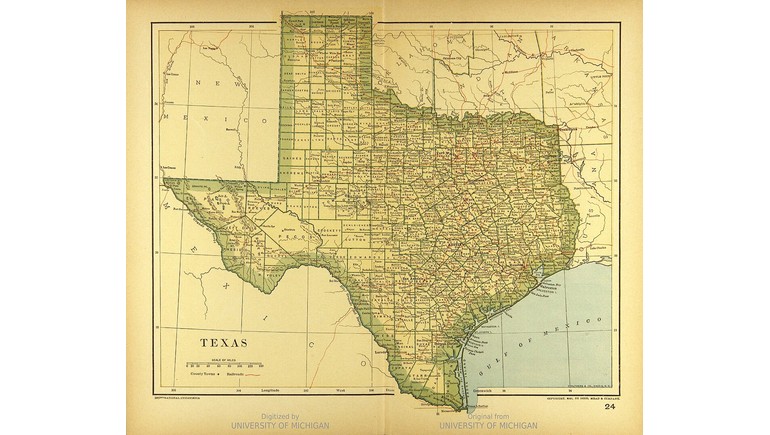
The 1894 Map of Texas provides a historical look at the state's geography, transportation routes, and political boundaries during the late 19th century. Published by Dodd, Mead, and Company as part of The Universal Atlas, the map captures Texas during a period of economic growth, railroad expansion, and increasing settlement. It offers a valuable reference for understanding how the state was organized more than a century ago.
Texas in the Late 19th Century
By 1894, Texas had been part of the United States for nearly 50 years. The state had experienced major changes since joining the Union in 1845, including the Civil War, Reconstruction, and the expansion of agriculture and ranching.
During the late 1800s, Texas was becoming increasingly connected to the rest of the country through railroads and commercial development. Cities such as Dallas, Houston, San Antonio, Austin, and Galveston were important centers of business, government, and transportation.
The map reflects this period of development, showing the geographic organization of Texas before the widespread use of automobiles and modern highways.
Counties, Cities, and Geographic Features
One of the map's most useful features is its representation of Texas counties and their boundaries. County divisions were important for local government, land ownership, transportation planning, and regional administration.
The map also identifies cities, towns, rivers, and other geographic landmarks. Major waterways, including the Rio Grande, Brazos River, Colorado River, and Red River, help define the state's natural landscape.
These details provide a historical reference for comparing the locations of settlements and geographic features with those found on modern Texas maps.
Railroads and Transportation in 1894
Railroads played a major role in the development of Texas during the late 19th century. Before automobiles became widely available, trains were among the most important methods of transporting passengers, agricultural products, livestock, and manufactured goods.
Railway expansion encouraged the establishment of new communities and helped existing towns grow into commercial centers. Connections between farming regions, ranching areas, and major cities contributed to economic development throughout the state.
Historical maps from this period illustrate the importance of transportation routes in determining where towns and industries developed.
Texas Before Modern Urban Expansion
In 1894, much of Texas remained predominantly rural. Farming, cattle ranching, and railroad-related commerce supported many communities, while large areas of West Texas and the Panhandle had relatively low population densities.
The state's major cities were considerably smaller than they are today. Modern metropolitan areas, interstate highways, and extensive suburban developments had not yet transformed the landscape.
Comparing the 1894 map with a present-day Texas map reveals how population growth, industrial development, and transportation improvements have reshaped the state.
Historical Importance of the Map
The 1894 Map of Texas is a valuable example of late 19th-century American cartography. Its detailed geographic information reflects how publishers documented states and territories for educational, commercial, and general reference purposes.
Today, the map provides a useful resource for studying Texas history, historical geography, county boundaries, and settlement patterns. It also offers a glimpse of Texas at a time when railroads, agriculture, and expanding communities were shaping the state's future.
By preserving the geographic knowledge of its era, the map helps illustrate how Texas developed from a largely rural state into one of the country's major economic and population centers.