


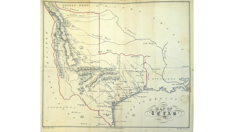
The 1841 Ikin Map of Texas provides a historical view of the state during its years as an independent republic. Created by Arthur Ikin and published in London, the map illustrates Texas's geography, settlements, rivers, and territorial boundaries during the early 19th century. It was included in Ikin's publication Texas, Its History, Topography, Agriculture, Commerce, and General Statistics, offering readers a geographic reference to a region that was attracting growing international attention.
Texas During the Republic Era
In 1841, Texas was an independent nation known as the Republic of Texas. The republic had declared independence from Mexico in 1836 and would remain a separate country until joining the United States in 1845.
During this period, Texas faced numerous challenges, including financial difficulties, political disputes, conflicts with Mexico, and tensions involving Indigenous nations. Despite these challenges, the republic continued to attract settlers and investors interested in its agricultural land and economic opportunities.
The Ikin map captures Texas during this important period, showing how the region was understood and represented before American annexation.
Territorial Boundaries and Geographic Features
One of the map's most interesting features is its depiction of Texas's extensive territorial claims. During the republic era, Texas claimed land extending far beyond its present-day borders, including areas that would eventually become parts of several other U.S. states.
These boundaries reflected the republic's political claims rather than territory it fully controlled. Mexico continued to dispute Texas independence, while Indigenous nations maintained authority over substantial areas.
The map also identifies major rivers and geographic features that influenced settlement and transportation. Waterways such as the Brazos, Colorado, Trinity, and Red River played important roles in the development of early Texas communities.
Early Settlements and Transportation
During the 1840s, much of Texas remained rural, with settlements concentrated primarily in eastern and central regions. Communities such as Houston, Austin, San Antonio, Galveston, and Nacogdoches were important centers of government, trade, and population.
Transportation depended heavily on rivers, coastal shipping, horseback travel, and overland roads. Modern highways and extensive railroad networks had not yet developed, making geographic knowledge essential for merchants, settlers, and travelers.
Historical maps like Ikin's helped readers understand the distances between communities and the natural features that influenced travel across Texas.
Arthur Ikin and Early Texas Cartography
Arthur Ikin was a British writer associated with the promotion and documentation of Texas during the republic era. His 1841 publication provided information about the region's history, geography, agricultural potential, commerce, and population.
The accompanying map was produced as a lithograph by J. & C. Walker, a British cartographic firm. It reflects the growing international interest in Texas during a period when the republic was seeking economic opportunities and diplomatic recognition.
The map also demonstrates how European publishers represented Texas to readers who may have known relatively little about the newly independent nation.
Historical Importance of the Map
The 1841 Ikin Map of Texas is an important example of cartography from the Republic of Texas period. It documents the region before statehood and provides insight into the geographic information available to international audiences during the early 1840s.
Comparing this map with modern Texas maps reveals significant changes in political boundaries, settlement patterns, transportation routes, and geographic knowledge.
Today, the map serves as a valuable historical resource for studying the Republic of Texas, territorial expansion, early settlements, and the state's development before joining the United States.