


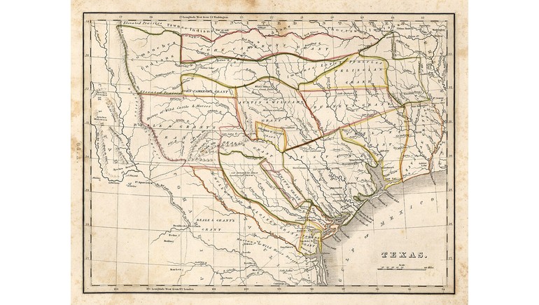
The 1835 Bradford Map of Texas provides a historical look at the region shortly before the Texas Revolution and its independence from Mexico. Created by American cartographer Thomas Gamaliel Bradford, the map was published in his Comprehensive Atlas, Geographical, Historical and Commercial. It is recognized as the first separate map of Texas to appear in an atlas, making it an important example of early Texas cartography.
Texas Before Independence
In 1835, Texas was still part of Mexico, although tensions between Mexican authorities and Anglo-American settlers were increasing. Disagreements over political authority, immigration, and the Mexican government's centralization of power contributed to the growing movement for independence.
The Bradford map captures Texas during this period of political uncertainty. It was published the same year the Texas Revolution began, just months before Texas declared independence on March 2, 1836.
At the time, much of the region was sparsely settled by newcomers, while Indigenous peoples continued to occupy and control extensive territories. The map reflects the geographic knowledge and political perspectives of American cartographers during the early 19th century.
Land Grants and Early Settlements
One of the map's most distinctive features is its use of different colors to identify major land grants and settlement regions. These areas include territories associated with early colonization efforts, particularly those of Stephen F. Austin and other empresarios who received permission from Mexican authorities to establish settlements.
The map also identifies important towns, settlements, and transportation routes. Places such as San Antonio, Nacogdoches, and San Felipe de Austin were significant centers of population, government, and commerce during the Mexican Texas period.
These details provide a useful reference for understanding how settlement patterns were developing before Texas became an independent republic.
Rivers and Geographic Features
The Bradford map includes numerous geographic features that shaped the region's early development. Major rivers such as the Brazos, Colorado, Trinity, and Red River appear alongside smaller waterways and other natural landmarks.
Rivers were particularly important during the 1830s because they influenced settlement locations, transportation, agriculture, and trade. Many early communities developed near reliable water sources and accessible routes.
The map also identifies prairies, hills, and other physical features, illustrating the varied landscape of Texas before large-scale urban and industrial development.
An Important Map in Texas Cartography
Thomas Gamaliel Bradford was an American cartographer and publisher known for producing geographical reference materials during the 19th century. His 1835 atlas included maps of states and territories, providing readers with geographic information about North America and other parts of the world.
The inclusion of Texas as a separate map was particularly significant because the region was attracting increasing attention from American settlers, investors, and political observers.
The Bradford map also includes descriptive information about Texas, offering contemporary observations of the territory's geography and natural environment.
Historical Importance of the Map
The 1835 Bradford Map of Texas is valuable because it documents the region immediately before one of the most important events in its history. Within a year of its publication, Texas would declare independence from Mexico and establish the Republic of Texas.
Comparing this map with later maps reveals significant changes in political boundaries, settlement patterns, and geographic knowledge. It also illustrates how cartographers represented Texas during a period when its political future remained uncertain.
Today, the map serves as an important historical resource for understanding Mexican Texas, early colonization, and the geographic conditions that preceded the Texas Revolution.