


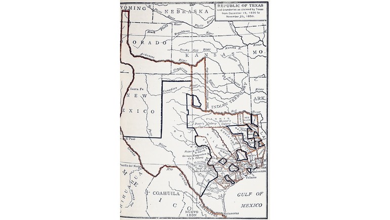
The Map of the Republic of Texas and Its Claimed Boundaries, 1836–1850, illustrates the extensive territory Texas claimed during its years as an independent republic and its early period of American statehood. Created by Z. T. Fulmore and published in 1926, the historical map shows how Texas once claimed lands far beyond its present-day borders. It provides an interesting look at the political and territorial changes that shaped the state's geography during the 19th century.
Texas as an Independent Republic
Texas declared independence from Mexico on March 2, 1836, following months of armed conflict during the Texas Revolution. After securing its independence, Texas established the Republic of Texas, which existed as a separate nation until joining the United States in 1845.
During this period, the republic claimed a much larger territory than modern Texas. Its government asserted that the Rio Grande formed its southern and western boundary, extending the claimed territory northward into areas that are now part of several other states.
However, these claims were disputed, and the Republic of Texas never established effective control over much of the territory it claimed.
The Expansive Boundaries of Early Texas
One of the map's most notable features is its depiction of the extensive territorial claims made by Texas between 1836 and 1850. These claims included parts of present-day New Mexico, Colorado, Kansas, Oklahoma, and Wyoming.
The claimed western boundary followed the Rio Grande northward, reaching far beyond the borders familiar to Texans today. This produced a much larger and differently shaped territory than the modern state.
The map helps illustrate the distinction between land claimed by the Texas government and territory it actually administered. Much of the disputed region remained under Mexican or Indigenous control during the republic's existence.
Texas Annexation and Border Disputes
Texas officially joined the United States on December 29, 1845, becoming the 28th state. However, annexation did not immediately resolve its territorial disputes.
The disagreement over the southern boundary between Texas and Mexico contributed to the tensions that led to the Mexican-American War in 1846. The conflict ended with the Treaty of Guadalupe Hidalgo in 1848, which established the Rio Grande as the international boundary.
Meanwhile, Texas continued to claim extensive territory in present-day New Mexico, creating another dispute between the state and the federal government.
The Compromise of 1850
The territorial claims illustrated on the map were significantly reduced through the Compromise of 1850. Under the agreement, Texas relinquished its claims to large areas of land that would eventually become parts of New Mexico, Colorado, Kansas, Oklahoma, and Wyoming.
In exchange, the federal government agreed to provide Texas with $10 million, which helped the state address debts accumulated during its years as an independent republic.
The agreement established much of Texas's modern northern and western boundaries and resolved a major territorial disagreement between the state and the federal government.
Historical Importance of the Map
The map is particularly valuable because it illustrates how dramatically Texas's territorial claims changed between independence and the Compromise of 1850.
Although published in 1926, the map represents an earlier period when Texas was transitioning from an independent republic into an American state. It provides a useful geographic reference for understanding the state's territorial ambitions, political disputes, and changing borders.
Today, the map serves as an important historical resource for studying the Republic of Texas, American westward expansion, and the development of Texas's modern boundaries. It also explains why the state's familiar geographic shape differs so greatly from the territory once claimed by its early government.