


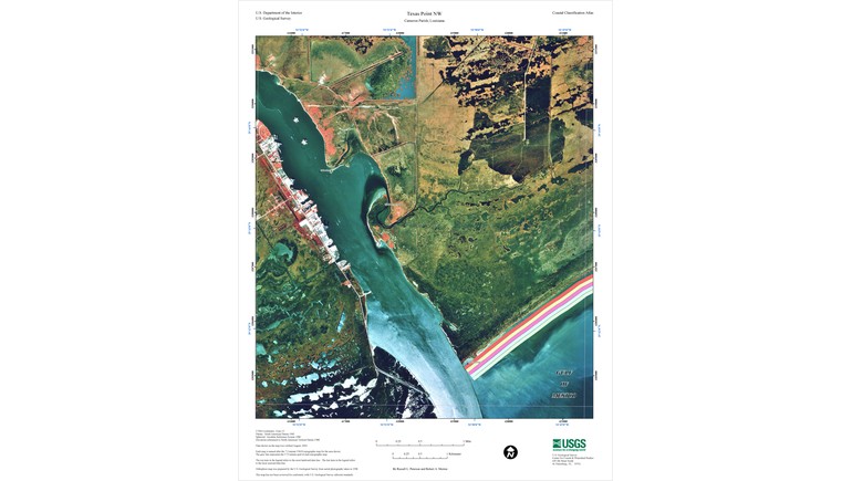
The 2004 USGS Map of Sabine Pass provides a detailed geographic view of the coastal waterway located along the border between Texas and Louisiana. Prepared by the United States Geological Survey (USGS) using aerial photography taken in 1998, the map illustrates the coastline, waterways, wetlands, and surrounding landscape of this important Gulf Coast region. It serves as a useful reference for understanding the natural geography and transportation importance of Sabine Pass.
Understanding Sabine Pass
Sabine Pass is a natural waterway connecting Sabine Lake with the Gulf of Mexico. Located along the southeastern border of Texas and southwestern Louisiana, the passage forms part of the boundary between the two states.
The waterway has historically been important for navigation, maritime trade, and coastal transportation. It provides access between inland waterways and the Gulf of Mexico, making it an important geographic feature for nearby communities and industrial facilities.
The map highlights the location of Sabine Pass and its relationship to the surrounding coastal environment.
Coastal Geography and Natural Features
One of the map's most interesting features is its detailed representation of the coastal landscape. The region contains extensive marshlands, tidal waterways, and low-lying coastal areas that are characteristic of the northern Gulf Coast.
Sabine Lake lies north of the pass, while the Gulf of Mexico extends to the south. These interconnected waterways create an estuarine environment where freshwater from inland rivers mixes with saltwater from the Gulf.
The surrounding wetlands provide important habitats for fish, birds, and other coastal wildlife. They also contribute to the natural processes that influence water movement, sediment deposition, and shoreline changes.
Navigation and Maritime Transportation
Sabine Pass has long served as an important maritime entrance to the ports and industrial facilities of Southeast Texas and Southwest Louisiana.
The waterway connects with the Sabine-Neches Waterway, which provides shipping access to major industrial and commercial centers, including Port Arthur, Beaumont, and Orange.
These connections have supported the development of petroleum refining, chemical manufacturing, shipping, and other industries throughout the region.
The map provides geographic context for understanding why this relatively narrow coastal passage is important to regional transportation and commerce.
Sabine Pass and Texas History
Sabine Pass also holds an important place in Texas military history. During the American Civil War, the area was the site of the Second Battle of Sabine Pass on September 8, 1863.
During the battle, a small Confederate force stationed at Fort Griffin successfully defended the passage against a larger Union naval expedition attempting to enter Texas.
The Confederate victory prevented the immediate Union invasion through Sabine Pass and became one of the state's best-known Civil War engagements.
Although the USGS map represents the region in modern times, it provides useful geographic context for understanding the location of this historic military encounter.
The Importance of Geographic Mapping
The 2004 Sabine Pass map is an orthophoto map, meaning it was created using aerial imagery that has been geometrically corrected to provide accurate geographic measurements.
This mapping technique allows users to examine natural and developed features while maintaining a consistent geographic scale.
Because the imagery was collected in 1998, the map also preserves a record of the coastline before several major hurricanes affected the northern Gulf Coast in subsequent years.
Historical aerial maps can help researchers compare changes in shorelines, wetlands, transportation infrastructure, and coastal development over time.
Historical and Geographic Importance of the Map
The USGS Map of Sabine Pass provides a valuable reference for understanding one of the most important coastal passages along the Texas-Louisiana border.
By documenting the arrangement of waterways, coastal landforms, and surrounding terrain, the map illustrates the relationship between natural geography and maritime transportation.
Today, it serves as a useful resource for studying Texas coastal geography, environmental changes, navigation routes, and the historical development of the Sabine Pass region.