


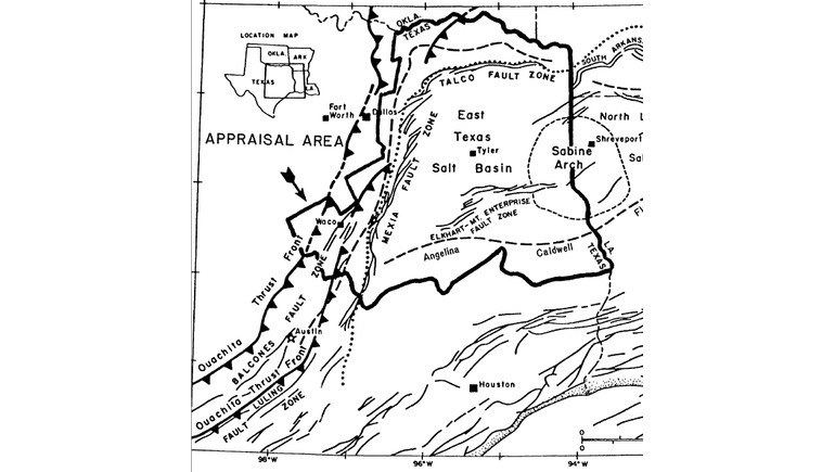
The 1988 East Texas Basin Geologic Map provides a detailed look at the geological structures beneath eastern Texas. Published by the United States Geological Survey (USGS), the map illustrates the region's geological formations, structural boundaries, and features associated with oil and natural gas deposits.
Understanding the East Texas Basin
The East Texas Basin is a large sedimentary basin located in the eastern part of Texas. Formed over millions of years, the basin contains thick layers of sedimentary rock that preserve evidence of the region's geological history.
These underground formations include sandstone, limestone, shale, and other rock types deposited during different geological periods. The basin is particularly important because it contains significant petroleum resources that have contributed to Texas's energy industry.
Geological Features and Structures
One of the map's most important features is its representation of the geological structures that define the East Texas Basin. These include faults, structural boundaries, and formations that influenced the movement and accumulation of oil and natural gas.
The region's geological development was shaped by ancient sediment deposition, underground salt movement, and tectonic activity. These processes created structures capable of trapping petroleum beneath the Earth's surface.
The map helps illustrate the relationship between these geological features and the distribution of natural resources across East Texas.
The East Texas Basin and Oil Production
The East Texas Basin played a major role in the development of the state's petroleum industry. The discovery of the East Texas Oil Field in 1930 transformed the regional economy and established the area as one of the most important oil-producing regions in the United States.
The field became famous for its enormous petroleum reserves, particularly within the Woodbine Formation, a geological unit dating to the Cretaceous Period.
Geological studies of the basin have helped researchers and petroleum companies understand where oil and natural gas deposits occur and how underground rock formations influence their distribution.
Historical and Scientific Importance
The 1988 map was included in a USGS study titled Petroleum Geology and the Distribution of Conventional Crude Oil, Natural Gas, and Natural Gas Liquids, East Texas Basin. Prepared by R.Q. Foote, L.M. Massingill, and R.H. Wells, the study documented the geological conditions associated with petroleum resources in the region.
Today, the map remains a useful historical and scientific reference for understanding the geological development of East Texas. It also demonstrates how geological mapping has supported natural resource exploration and contributed to knowledge of the state's underground formations.