


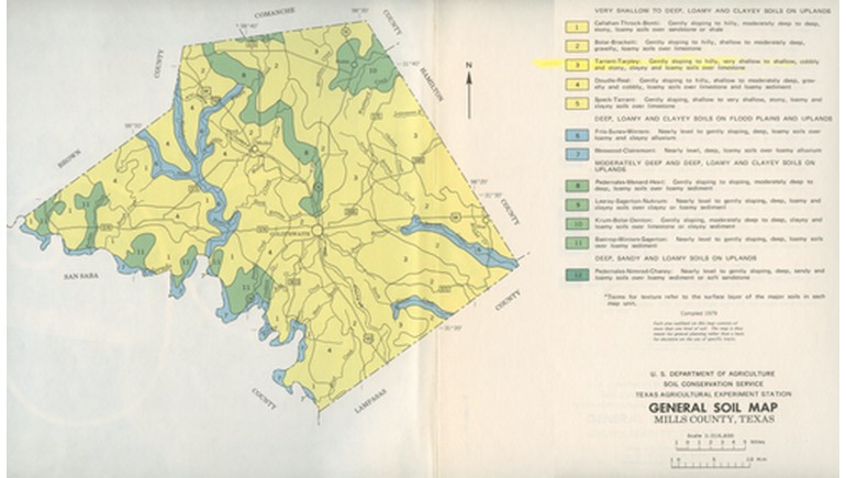
The 1979 Mills County Soil Map provides a detailed look at the different soil types found throughout Mills County in Central Texas. Prepared by the United States Department of Agriculture's Soil Conservation Service in cooperation with the Texas Agricultural Experiment Station, the map was included in the Soil Survey of Brown and Mills Counties, Texas, published in 1980.
Understanding the Soil Types of Mills County
Mills County is located in Central Texas, with Goldthwaite serving as its county seat. The area features rolling hills, valleys, grasslands, and agricultural land, with soil conditions varying across the landscape.
The map identifies different soil associations using numbered areas and a corresponding legend. These classifications help explain variations in soil depth, texture, and composition, which influence how land can be used for farming, grazing, and other purposes.
Soil Features and Geographic Details
One of the map's most notable features is its representation of different soil groups across the county. These include shallow to deep loamy and clayey soils found on uplands, along with other soil formations influenced by the region's underlying rock layers.
The map also identifies roads, railroads, creeks, towns, schools, churches, and utility infrastructure. These details provide geographic context and help illustrate how soil conditions relate to existing settlements and transportation routes.
A legend explains the soil classifications, while a scale of 1:316,800 allows readers to understand the approximate distances between locations.
Agriculture and Land Use in Mills County
Agriculture has long played an important role in Mills County's economy. Ranching, livestock production, and farming have influenced how land is managed throughout the region.
Understanding soil characteristics is especially important for agricultural planning. Soil depth, drainage, texture, and water-holding capacity affect the suitability of land for crops, pasture, and grazing.
The information presented in this map helped provide a scientific basis for land management, soil conservation, and agricultural development.
Historical and Scientific Importance
Although identified as a 1979 map, the Mills County General Soil Map was published in 1980 as part of a broader federal soil survey. It documents the county's soil distribution using the mapping methods and classifications available at that time.
Today, the map serves as a useful historical reference for studying Texas agriculture, soil conservation, and land use. Comparing it with modern soil surveys can help researchers understand changes in mapping techniques and land management practices over time.
It also demonstrates the importance of soil mapping in understanding the natural characteristics of Central Texas.