

Texas offers a diverse landscape, making it an ideal place for those looking to explore scenic drives. From rolling hills to rugged deserts, there are countless routes that showcase the state’s natural beauty and unique charm.
Drivers can choose from several remarkable options, each providing its own memorable views and experiences. Whether traveling by car or motorcycle, these scenic drives present a chance to see some of Texas’s most striking vistas and enjoy the open road.
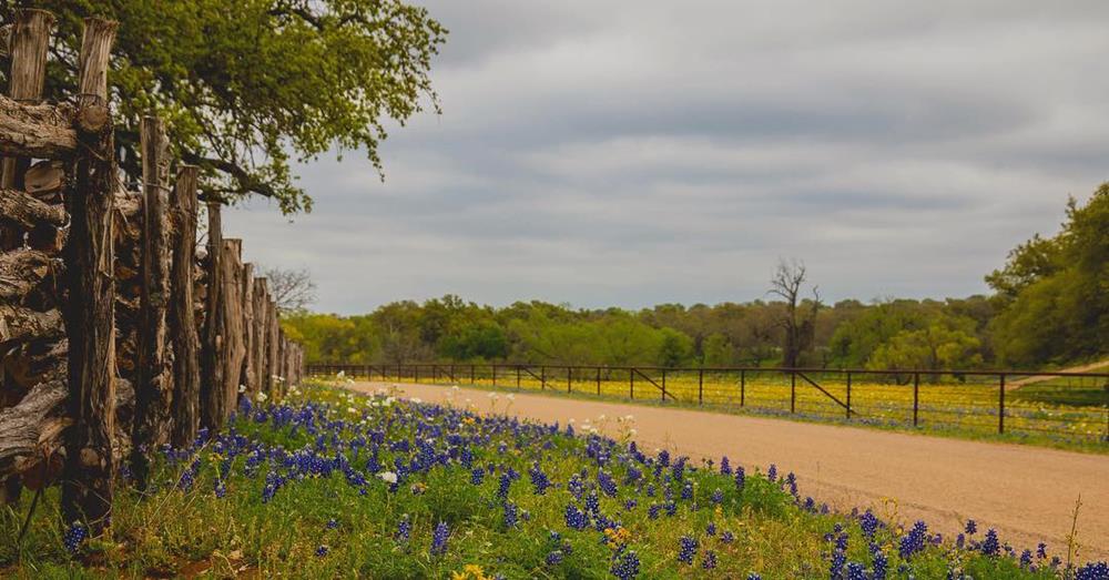
1. Bluebonnet Driving Route in Spring
In spring, the Bluebonnet Driving Route near Ennis is known for its stretch of approximately 40 miles lined with vivid wildflowers, most notably the bluebonnet. Travelers can expect scenic drives along winding rural roads, where historic farmhouses and fences are bordered by colorful blooms.
Peak viewing is usually mid-April, making it the ideal time to visit for anyone hoping to witness the bluebonnets at their brightest. Families, photographers, and nature enthusiasts often pull over at marked stopping points for photo opportunities and to enjoy the peaceful scenery.
Quick Facts
| Feature | Details |
|---|---|
| Bluebonnet Season | March–April |
| Peak Bloom | Mid-April |
| Route Length | ~40 miles |
| Popular Event | Ennis Wildflower Festival |
2. Willow City Loop
The Willow City Loop offers a 13-mile journey through some of the most striking scenery in the Texas Hill Country. Located north of Fredericksburg, this narrow ranch road travels past rocky hills, open meadows, and vibrant wildflower fields in spring.
Route Overview:
| Step | Direction | Distance |
|---|---|---|
| 1 | Take 16N (Llano Street) from Fredericksburg | 13.3 miles |
| 2 | Turn right onto RR1323 | 2.79 miles |
| 3 | Left onto Willow City Loop | 13 miles |
Travelers are greeted by a landscape dotted with limestone outcrops, seasonal creeks, and quiet ranches. Springtime brings a parade of colorful wildflowers, making March and April the prime months to visit for floral displays.
This private ranch road offers a peaceful drive ideal for those seeking tranquility amid natural surroundings. The loop is especially popular with photographers and anyone hoping to experience the characteristic beauty of rural Texas without the crowds.
3. FM 170 Scenic Byway Along the Rio Grande
FM 170, often called River Road, runs about 120 miles along the Rio Grande, connecting Terlingua and Presidio through the heart of West Texas. This winding roadway showcases striking desert scenery, with towering cliffs and the river serving as a natural border.
Travelers will encounter landmarks such as the old settlement of Lajitas and have opportunities to enter Big Bend Ranch State Park for further exploration. Highlights of the route include frequent pull-offs with wide views, making this a favorite for photographers and outdoor enthusiasts.
Key Details:
| Route | Main Features | Best Time to Visit |
|---|---|---|
| FM 170 | Rio Grande views, desert landscapes, Lajitas, Big Bend Ranch State Park access | October to April |
Travelers should bring supplies like water, as services are limited. Those in the area in early November might catch the local chili festival near Terlingua.
4. Devil’s Backbone Loop
View this post on Instagram
Travelers seeking scenic beauty in the Texas Hill Country often explore the Devil’s Backbone Loop, a 51-mile route connecting Wimberleyand Blanco. This loop follows Farm Roads 12, 165, 2325, and 32, along with U.S. Highway 281, weaving through hills, valleys, and vibrant landscapes.
Route Highlights:
- Top Views: Devil’s Backbone Overlook on FM 32 features sweeping vistas of hills and valleys.
- Photo Opportunities: Multiple pull-offs and scenic stops line the route, ideal for capturing memorable moments.
- Wildlife Watching: Visitors have opportunities to spot deer, birds, and other wildlife.
- Small Town Charm: Pass through historic communities featuring Texas Hill Country hospitality.
Seasonal Advice:
- Spring offers stunning wildflower displays.
- Autumn brings cooler air and changing foliage colors.
| Road Segments | Key Stops |
|---|---|
| FM 12, 165, 2325, 32, US-281 | Devil’s Backbone Overlook, Tavern, Wimberley, Blanco |
For a distinct local experience, the Devil’s Backbone Tavern provides refreshments and live music.
5. Big Bend Panoramic Loop
The Big Bend Panoramic Loop offers an extended road journey of over 200 miles, providing visitors with a comprehensive snapshot of Big Bend National Park’s varied landscape. Beginning in Marathon, travelers head south along US Highway 385, moving toward the primary entrance of the park and the Panther Junction Visitor Center, a practical hub for orientation and information.
Continuing deeper into the park, the route guides drivers to major features, including stops in the Chisos Basin and the iconic Santa Elena Canyon. The Ross Maxwell Scenic Drive, known for its access to dramatic overlooks and geologic features, is a critical segment. This portion offers easy pullouts for panoramic views and interpretive signs describing the area’s natural history.
Upon leaving the park’s west side, the drive passes near Terlingua, a historic ghost town distinguished by its quirky atmosphere and remnants of a storied mining past. From Terlingua, the route heads north on State Route 118 toward Alpine. Wrapping up the journey, drivers complete the loop by traveling east along US 90, returning to Marathon.
Key Highlights:
| Point of Interest | Features |
|---|---|
| Panther Junction | Park orientation, visitor center |
| Chisos Basin | Mountain scenery, short trails |
| Santa Elena Canyon | River views, hiking opportunities |
| Ross Maxwell Drive | Overlooks, geologic formations |
| Terlingua | Ghost town, local culture |
6. Ross Maxwell Route
View this post on Instagram
The Ross Maxwell Scenic Drive spans approximately 30 miles through Big Bend National Park, linking Panther Junction with iconic destinations such as Santa Elena Canyon and the Chisos Mountains. Travelers encounter varied desert scenery, including dramatic cliffs and wide-open vistas.
Key stops include Sotol Vista overlook, which provides sweeping views of the park, and Tuff Canyon, known for its accessible hiking trails. The road also passes several historic locations and geological features that reflect the area’s rich natural history.
Highlights:
- Scenic viewpoints
- Short hikes
- Geological and historic sites
7. Palo Duro Canyon Drive
The Palo Duro Canyon Loop is a 16-mile scenic route located within Palo Duro Canyon State Park, nestled in the Texas Panhandle. This drive descends from the canyon rim to the floor, offering a close look at multi-colored rock layers, towering cliffs, and distinctive mesas.
Notable stops include views of the well-known Lighthouse Rock, which stands as one of the canyon’s most recognized natural features.
Highlights of the Loop:
- 16-mile paved canyon drive
- Impressive viewpoints for photography
- Access to hiking trails and picnic spots
- Opportunities to spot native wildlife
| Landmark | Feature |
|---|---|
| Lighthouse Rock | Iconic hiking and photo spot |
| Visitor Center | Maps, exhibits, information |
8. Twisted Sisters Scenic Loop (Three Sisters)
View this post on Instagram
The Twisted Sisters, often called the Three Sisters, form a 100-mile scenic loop known for its tight curves and exciting elevation changes. This famed route follows Ranch Roads 335, 336, and 337, winding through the heart of Texas Hill Country. Drivers and motorcyclists encounter sharp turns, steep grades, and broad vistas over rugged terrain.
Highlights of the Drive:
| Feature | Details |
|---|---|
| Roads | RM 335, RM 336, RM 337 |
| Start/End | Medina |
| Length | 100 miles (approximate) |
| Best Times to Visit | Spring (wildflowers), Fall (colors) |
Highway 16 provides access to the beginning of this loop, which is sometimes nicknamed the “Texas Swiss Alps Scenic Drive” for its striking hillside views. Along the route, travelers can stop in small towns for refreshments and meet local residents.
Due to the challenging nature of the roads, it’s ideal for those seeking an exciting driving experience surrounded by natural beauty.
9. Davis Mountains Driving Loop
View this post on Instagram
Travelers can discover the rugged beauty of West Texas by taking the Davis Mountains Driving Loop, a 75-mile paved circuit that begins and ends in the historic town of Fort Davis. The route follows TX-118 and TX-166, navigating through mountainous terrain with elevations that provide cooler temperatures than much of the surrounding region.
Along the drive, visitors will encounter scenic overlooks, desert flora, and diverse wildlife, making stops for photographs and short hikes easy and enjoyable.
A highlight of the loop is the McDonald Observatory, where guests can participate in star-gazing events and take in panoramic views of the clear night sky. The loop’s high elevation and landscape offer a refreshing environment especially appealing during the summer months.
Below is a summary of key features:
| Feature | Details |
|---|---|
| Total Distance | 75 miles |
| Main Highways | TX-118, TX-166 |
| Notable Stop | McDonald Observatory |
| Starting/Ending Point | Fort Davis |
| Best Season to Visit | June–August (cooler and clear nights) |
This drive offers a chance to enjoy impressive mountain scenery and a unique perspective on Texas’s natural environment.
Top Picks
Best Scenic Drives for Spring Flowers 🌸
Travelers looking for seasonal wildflower displays should try routes near Ennis, especially during the spring bloom when bluebonnets dominate the region. The Willow City Loop, found in the heart of Hill Country, is another brief but vibrant journey known for its diverse blooms and picturesque farmland views.
Top Routes for Mountain Scenery 🏞
The Davis Mountains loop in West Texas presents some of the most impressive high-elevation roadways in the state. Drivers can expect panoramic views, rolling hills, and a chance to spot local wildlife unique to this remote area.
Noteworthy Drives for Desert Views 🌄
For wide-open spaces and striking geology, both the River Road along the Rio Grande and the Big Bend Scenic Loop stand out. These routes cross sprawling deserts, winding past rugged canyons and historic sites. The Ross Maxwell Scenic Drive highlights the dramatic features inside Big Bend National Park, including sweeping overlooks.
| Route | Features | Region |
|---|---|---|
| River Road (FM 170) | Desert scenery, river | West Texas/Big Bend |
| Ross Maxwell Drive | Rock formations, ruins | Big Bend National Park |
Short Scenic Routes for Quick Trips 🚗
Palo Duro Canyon Loop provides travelers access to the awe-inspiring colors and formations of the nation’s second-largest canyon in a manageable distance. Willow City Loop doubles as both a flower-viewing route in spring and a convenient short drive year-round.
Best Loops for Motorcycle Enthusiasts 🏍
Those traveling by motorcycle frequently seek out the “Twisted Sisters.” This Hill Country route is well-regarded for its sharp turns, elevation changes, and panoramic scenery — ensuring a memorable ride. Galveston Island‘s coastal roads, alongside views of the Gulf of Mexico, can also appeal to riders looking for ocean breezes and open sky.