


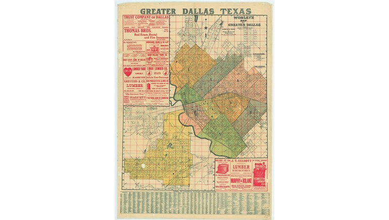
The 1905 Map of Dallas, Texas, provides a detailed historical view of the city during the early 20th century. Originally published by John F. Worley & Co., the map illustrates Dallas's street network and urban layout at a time when the city was experiencing significant commercial and population growth. It offers a valuable reference for understanding how Dallas looked before the development of modern highways, skyscrapers, and expansive suburban neighborhoods.
Dallas in the Early 1900s
By 1905, Dallas had established itself as an important commercial and transportation center in North Texas. Its economy was supported by agriculture, manufacturing, wholesale trade, and railroad connections that linked the city with other parts of Texas and the United States.
The city had grown considerably since its founding in 1841. New businesses, residential neighborhoods, and transportation facilities were transforming Dallas into a major regional center.
The 1905 map captures this period of development, documenting the city's geographic organization during an important stage of its expansion.
Streets and Urban Development
One of the map's most interesting features is its representation of Dallas's early street layout. The network of streets and city blocks reflects the organized development of residential and commercial areas during the late 19th and early 20th centuries.
Downtown Dallas served as the center of business activity, with surrounding neighborhoods developing as the population increased. Streets provided connections between commercial districts, residential communities, and transportation facilities.
Comparing this map with a modern street map reveals how many historic roads have remained part of Dallas's transportation system, even as the surrounding city has changed dramatically.
Railroads and Transportation
Railroads played a major role in Dallas's growth during the early 1900s. The city's location along several important railway routes helped establish it as a center for distributing agricultural products, manufactured goods, and commercial supplies.
Before automobiles became the primary means of transportation, residents depended on railroads, streetcars, horse-drawn vehicles, and pedestrian routes to travel throughout the city.
Streetcar systems were particularly important in connecting downtown Dallas with expanding residential neighborhoods. These transportation improvements encouraged development beyond the original city center.
Dallas Before Modern Expansion
In 1905, Dallas was considerably smaller than the metropolitan area known today. Much of the surrounding land remained agricultural or undeveloped, while residential neighborhoods were concentrated closer to the city's commercial center.
The construction of major highways, airports, office towers, and suburban communities would dramatically transform the region throughout the 20th century.
The historical map provides an opportunity to examine Dallas before these changes, helping illustrate the relationship between its early street network and modern urban development.
Historical Importance of the Map
The 1905 Dallas Map is a valuable example of early American urban cartography. Published by John F. Worley & Co., it documents the city's layout during a period when Dallas was emerging as one of Texas's leading commercial centers.
Today, the map serves as a useful resource for studying local history, historic neighborhoods, transportation development, and changing street patterns.
Comparing the 1905 map with modern maps highlights more than a century of urban expansion and demonstrates how Dallas developed from a regional trading center into one of the largest cities in the United States.