
When you think of Texas, you probably conjure up images of sprawling ranches, vibrant country music scenes, and hearty Texas barbecue often come to mind. However, lurking beneath this iconic imagery lies a lesser-known yet equally fascinating feature of the Lone Star State – its volcanoes. Yes, you read that correctly – Texas, a land often associated with cowboys and oil rigs, is also home to ancient volcanic structures. So yes, there are volcanoes in Texas!
In this post, we’ll explore the hidden volcanic landscape of Texas.

Pilot Knob
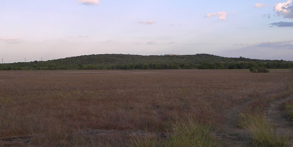

Located near Austin, Pilot Knob stands as an eroded remnant of a once-active volcanic complex. This geological wonder, which ceased activity over 80 million years ago, was extremely active during its time. Although now appearing as a small hill, it is the largest extinct volcano in Central Texas, spanning over two miles in diameter.
During the Cretaceous period, when Pilot Knob was active, the area was covered by a shallow sea, bustling with marine life and frequented by dinosaurs. The volcanic activity included explosive steam eruptions as seawater interacted with hot magma. These eruptions contributed significantly to the local soil fertility, enhancing agriculture in the region. Today, Pilot Knob’s remnants can be seen near McKinney Falls State Park, offering a glimpse into the volcanic past of Central Texas.
Mitre Peak
Mitre Peak is a notable geological feature located eleven miles southeast of Fort Davis, Texas. Rising to an elevation of 6,190 feet, Mitre Peak stands prominently above the surrounding terrain due to its nature as a conical intrusive mass. The peak is formed from harder rock that has resisted erosion compared to the softer surrounding rock, making it a distinct landmark in the region.
This geological formation supports a variety of scrub brush and grasses adapted to the shallow, stony soils of the area. The peak is named for its resemblance to the mitre headwear traditionally worn by bishops, underscoring its unique and pointed shape.
Paisano Pass
Paisano Pass is located along U.S. Route 90 between Alpine and Marfa in Texas. The area is geologically significant due to the presence of the Paisano Volcano, a collapsed volcanic crater that erupted about 35 million years ago.
As you drive through the pass, you can observe light-colored syenite, which is similar in appearance to granite. This geological feature is part of the broader Trans-Pecos volcanic field, which began forming nearly 48 million years ago. The remnants of these ancient volcanic activities are visible across a vast area extending from El Paso to the Chisos Basin.
Tuff Canyon
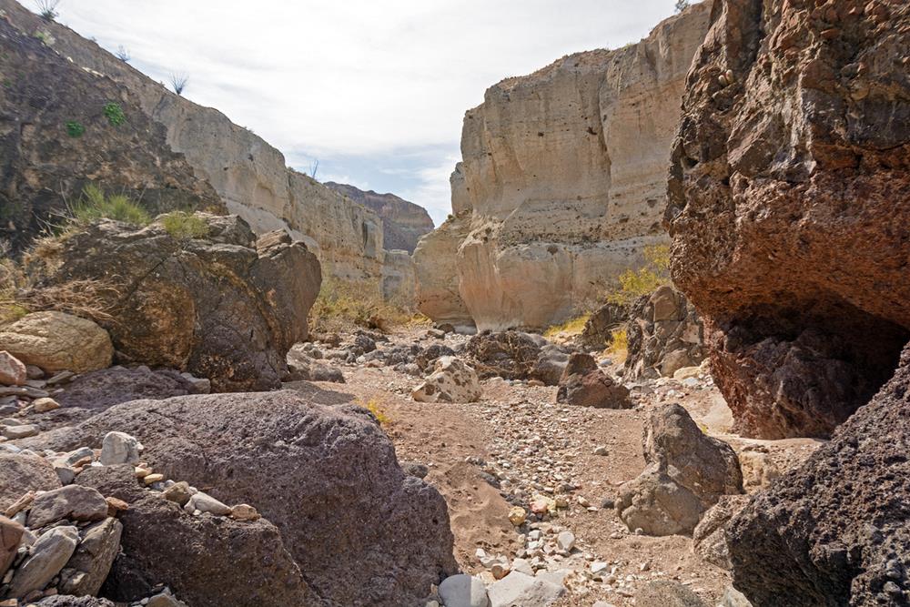

Tuff Canyon, located in Big Bend National Park, offers a fascinating glimpse into the region’s volcanic history. Formed by the accumulation of volcanic ash approximately 30 million years ago, the canyon features layers of volcanic tuff—a rock made from compressed volcanic ash. Over millennia, erosion primarily driven by water flow from Blue Creek has sculpted these layers into the dramatic canyon visible today.
The canyon’s formation began with eruptions that expelled vast amounts of ash, which settled and welded together under heat and pressure to form tuff. This geological process created a landscape that is both rugged and delicate, where the tuff, despite its hardness, remains susceptible to erosion. The walls of Tuff Canyon display a mix of this light volcanic tuff and older, darker basaltic rock, offering a stark visual contrast and a record of the area’s dynamic geological activity.
Visitors to Tuff Canyon can explore this unique terrain via a series of short trails leading to various overlooks, which provide expansive views of the canyon’s striking features.
Davis Mountains
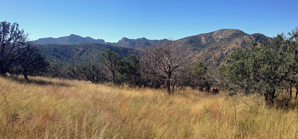

The Davis Mountains, a striking range in West Texas, are a product of volcanic activity from about 35 million years ago. Known as the Texas Alps, it is the second-highest mountain range in Texas. Visitors to the Davis Mountains State Park can witness the beauty of these ancient volcanoes and explore their rich geological heritage.
These mountains are composed of various volcanic strata originating from magma. Key volcanic centers contributing to their formation include the Paisano Volcano and the Buckhorn Caldera (see details below). The mountains, with their highest point at Mount Livermore, stand out in the West Texas landscape, offering lush vegetation distinct from the surrounding desert due to higher rainfall in the area. European explorers explored these areas in the 16th century, later becoming important locations during westward expansion in the 19th century.
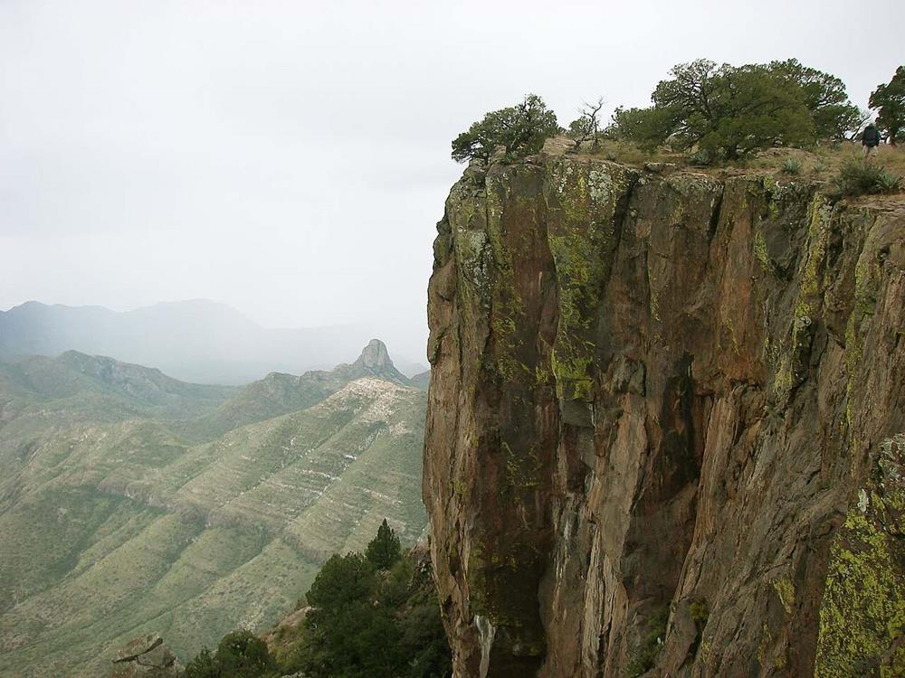
Big Bend National Park
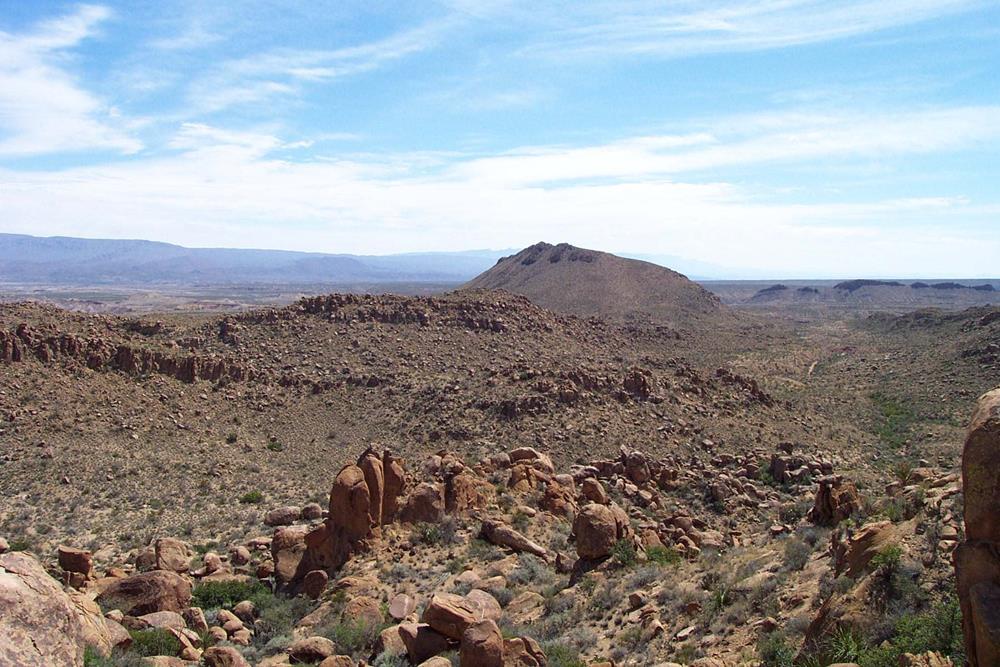
Big Bend National Park is a geological treasure trove renowned for its extensive volcanic history. The park’s landscape has been significantly shaped by a series of volcanic eruptions that began about 42 million years ago.
The first eruption in the region created the uplift of the area now known as the Christmas Mountains. Over time, between 38 and 32 million years ago, more volcanic eruptions occurred within the park itself, particularly in areas like the Sierra Quemada, Pine Canyon, Burro Mesa, and Castolon. These events gave rise to the colorful volcanic ash and layered lava formations that are so characteristic of the park today, especially in the lower elevations and the Chisos Mountains.
Big Bend’s volcanic activity was marked by long intervals of dormancy, during which erosion continually reshaped the landscape and life forms gradually colonized the newly formed habitats. This interplay between volcanic activity and erosion has led to the park’s current appearance, where erosive forces are still active.
Interestingly, about 26 million years ago, the central area of Big Bend was subjected to significant geological shifts. The formation of fracture zones due to the stretching of the continental plate caused large portions of the park’s central mass to drop downwards, creating a noticeable disparity in height between the lower desert and the higher surrounding mountain ranges.
Balcones Volcano
The Balcones Volcano in Central Texas significantly shaped the region’s topography. The volcanic activity here led to the formation of the Balcones Fault zone, a major geological feature. The area’s varied landscape, with its rolling hills and valleys, is also a direct result of the ancient volcanic activity.
Uvalde Volcano
This lesser-known volcanic site in Uvalde County is a fascinating geological feature that has drawn the attention of researchers and enthusiasts alike. The Uvalde Volcano last erupted approximately 35 million years ago has left behind a fascinating array of igneous rocks and formations, especially the remnants of a volcanic neck made primarily of basalt.
Surrounding the basaltic core, one can find pyroclastic materials ranging from fine-grained substances to volcanic bombs. These materials formed the slope of the volcano and are now visible in the eroded and dissected outcrop. This volcano is part of the Edwards Plateau region, which features various formations dipping gently toward the south and southeast, indicating the extensive and complex volcanic history that shaped the landscape. Today, the area provides a quiet retreat for nature lovers and geology buffs alike.
Cornudas Vents
Located in the remote corners of West Texas, the Cornudas Vents are another set of volcanic remnants, part of a larger volcanic field that extends into New Mexico. These mountains, characterized by rugged peaks and unique rock formations, serve as a reminder of the extensive volcanic activity that once dominated the region.
The Cornudas Vents in Texas, which are around 35 million years old, were initially formed underground and, over time, have been exposed due to erosion. The revealing of these ancient structures offers a unique insight into the volcanic activity that occurred in the region millions of years ago.
Buckhorn Caldera
The Buckhorn Caldera, located in the Davis Mountains of West Texas, is a significant geological feature representing the region’s volcanic past. However, detailed and specific information regarding its volcanic activity and transformation over time is limited compared to other volcanic sites in Texas.
The Davis Mountains, including the Buckhorn Caldera, were formed around 35 million years ago during a period of intense volcanic activity. The region consists of various volcanic strata formed from magma erupted from different volcanic centers. The presence of the Buckhorn Caldera and other related volcanic features illustrates the extensive and dynamic volcanic history that shaped the landscape of West Texas.
Today, the Davis Mountains, including the Buckhorn Caldera, offer a unique and rugged landscape that tells the story of the region’s volcanic past. The area is a testament to the significant geological forces that have shaped Texas’s landscape over millions of years.
Mount Bonnell
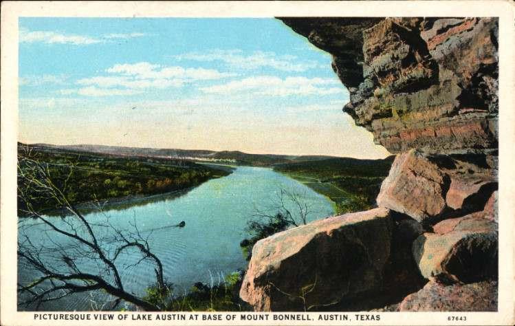

Mount Bonnell, located in Austin, Texas, is not just a popular sightseeing destination but also a site of geological significance. This natural landmark is part of the Balcones Fault Zone, Texas’s major geological fault line. The formation of Mount Bonnell is closely tied to the Balcones Fault, as it forms part of the Balcones Escarpment, a steep cliff or slope resulting from displacement along the fault. The area showcases limestone outcrops from the Lower Cretaceous Glen Rose Formation, indicative of the geological history of Central Texas.
The geological makeup of Mount Bonnell includes the Lower Cretaceous Trinity Group, Edwards Group, and Georgetown Formation. The rock strata here contain various formations like the Hammett Formation, Cow Creek Formation, and Hensel Formation, among others. These formations play a crucial role in the aquifers of the region, affecting groundwater flow and availability.
Mount Bonnell’s fault has a vertical throw of up to 600 feet, making it a prominent feature within the Balcones Fault Zone. The area underwent significant geological transformation during the Miocene Epoch, with the Edwards Group being displaced downwards relative to the Glen Rose Formation.
Sierra Blanca
Located in Hudspeth County, Sierra Blanca is a complex of volcanic mountains. Although it’s not a single volcano, the range includes volcanic features and is a part of the Trans-Pecos Volcanism region.
This range is distinctive for its three conical volcanic peaks: Sierra Blanca (the highest, at 6,891 feet), Little Blanca Mountain, and Round Top. The Sierra Blanca range marks a significant point in the geology of West Texas, with its volcanic peaks contributing to the region’s diverse landscape. The area is characterized by a combination of clay and sandy loams that support scrub brush and grasses. Its volcanic origins and the presence of volcanic rocks in the area were significant enough for NASA to use it as a training ground for the Apollo 11 astronauts, providing them with a lunar-like environment on Earth.
Hueco Tanks State Park & Historic Site
Hueco Tanks State Park & Historic Site, although not formed through volcanic activity, is an area of significant geological interest. This park is renowned for its large rock basins or “huecos” formed in volcanic rock. The natural rock basins have been shaped by erosion and weathering over time.
Hueco Tanks is not only a geological wonder but also a site of cultural and historical importance, with a rich history that includes ancient pictographs. It’s a unique location that offers insight into the natural processes that shape such landscapes and the human history intertwined with these geological features.
Elephant Mountain Wildlife Management Area
Elephant Mountain Wildlife Management Area, sprawling over 23,147 acres in West Texas, features a prominent mountain that is volcanic in origin. The area is predominantly characterized by Elephant Mountain itself, which is an igneous formation rising nearly 2,000 feet above the surrounding terrain. The peak reaches 6,225 feet above sea level, covering an area of over 2,200 acres.
Due to its significant elevation and unique geology, Elephant Mountain has become a critical habitat for the desert bighorn sheep. The terrain and ecology also support other wildlife, such as desert mule deer, pronghorn antelope, coyotes, and various bird species. The landscape is a mix of desert scrub, grassland, riparian zones, woodlands, and canyon woodlands, which has been altered to some extent by human activities like grazing and agriculture. The Elephant Mountain WMA, with its diverse habitats, serves as a crucial area for wildlife research, conservation efforts, and controlled public hunting.
Chisos Mountains

The Chisos Mountains, located in Big Bend National Park, are of significant geological and ecological interest. Formed from volcanic activity about 30 million years ago, these mountains are unique in their origin and composition. This range includes various volcanic rock types and formations resulting from ancient eruptions.
The mountains provide a home to a rich biodiversity, including a range of plant and animal species that thrive in this unique ecosystem. The Chisos Mountains offer not just a glimpse into the volcanic past of Texas but also a habitat that is diverse and ecologically rich. The area is a prime location for hiking, wildlife viewing, and experiencing the natural beauty of Texas’ volcanic landscapes. Visitors are treated to dramatic volcanic rock formations and a diverse range of ecosystems.
Three Dike Hill
Three Dike Hill, located in the southernmost part of Big Bend Ranch State Park, is an important geological site that’s about 27 million years old. The formation is known for its distinct dark basalt dikes that cut through softer, tuff layers and reach up to the hilltop. These dikes, which are large walls of igneous rock that cut through layers of other rock types, are visible reminders of the molten material that once flowed beneath the Earth’s surface in this area.
This structure is a clear indicator of the site’s volcanic past. Three Dike Hill is recognized as the last volcano to erupt in Texas. For visitors, the area offers camping opportunities at nearby sites in Big Bend Ranch State Park, with the volcanic formation providing spectacular views to wake up to.
Quitman Mountain Caldera Complex
The Quitman Mountains Caldera Complex in Hudspeth County is a series of calderas tracing back to the Eocene epoch, around 35 million years ago. This complex includes both intrusive and volcanic rocks. The landscape features craggy volcanic peaks that contrast with lighter-colored sedimentary rocks from the Cretaceous period.
This caldera complex dramatically shapes the horizon, especially when viewed from Interstate 10 traveling west from Van Horn. Now heavily eroded, the Quitman Mountains offer a vivid example of the transformative power of volcanic forces over the Texas landscape.
Conclusion
The volcanic history of Texas is as vast and varied as the state itself. From the eroded remnants of ancient volcanoes to the rugged landscapes shaped by molten rock, these sites offer a unique window into the Earth’s tumultuous past. Exploring these geological treasures not only provides a unique adventure but also a deeper appreciation for the natural history of the Lone Star State. So, the next time you find yourself in Texas, consider taking a journey into its volcanic past – it’s an experience that’s sure to leave a lasting impression.


