
Texas highway loops are bypass routes that connect multiple highways around urban areas. They emerged in 1931 through TxDOT planning and expanded considerably after World War II. Despite their name, not all loops form complete circles—like Austin’s Loop 360 or Dallas’s Loop 12. They’ve dramatically reduced congestion, boosted property values, and transformed commerce in cities like Houston, Dallas, and San Antonio. These transportation arteries reveal much about Texas’s growth and development priorities.
History and Evolution of Texas Highway Loops
While many motorists today take Texas’ elaborate system of highway loops for granted, these indispensable transportation links have roots stretching back nearly a century. The concept first emerged in 1933, when the Texas Department of Transportation began planning bypass routes around major urban centers like Houston.
The development accelerated in the post-World War II era as the state committed to building an extensive road system. Between the 1940s and 1970s, loops such as Houston’s Loop 610 were gradually approved and constructed.
These circular highways gained additional importance when incorporated into the Federal-Aid Highway Act of 1956. Texas highway loops were strategically designed to connect multiple state and U.S. highways, though not all form complete circles. They represent a pivotal component of Texas’ transportation infrastructure evolution.
Definition and Purpose of State Highway Loops
State highway loops in Texas serve as pivotal bypass routes connecting multiple highways while offering alternate pathways around congested urban areas. You’ll find these loops numbered chronologically within the Texas State Highway System, with lower numbers indicating older established routes.
The TxDOT Planning and Programming Division designs these loops to integrate with the Interstate Highway System, creating a comprehensive highway network throughout the state. While they’re called “loops,” not all form complete circles—many simply link two or more highways to provide alternative routes.
The highway system consists of both highway loops and spurs, with Loop 610 in Houston exemplifying their purpose: creating a 42-mile circular route around the city center, enabling efficient transportation planning and traffic management across metropolitan regions. Following the Colson-Briscoe Act of 1949, these loop systems received substantial funding that accelerated their development throughout Texas cities.
Major Loop Systems in Texas Urban Areas

Texas’s largest urban centers feature extensive loop highway systems that function as critical transportation corridors for millions of commuters daily. Houston’s Interstate 610 spans approximately 42 miles, divided into four segments that encircle the city’s core.
In the Dallas-Fort Worth metroplex, you’ll find Loop 12 surrounding Dallas proper, while Loop 820 encompasses the broader metropolitan area as part of the state’s highway system.
Austin features Loop 360 (Capital of Texas Highway), which connects major thoroughfares including U.S. Highway 183. El Paso’s system includes Loop 375 and the César Chávez Border Highway, developments overseen by the Texas Transportation Commission.
San Antonio boasts an impressive dual-loop configuration with Loop 410 serving as an inner beltway and Loop 1604 forming an outer ring exceeding 95 miles—one of the longest loops in Texas, reflecting the city’s expansive growth.
These loop systems are essential for navigating Texas’s vast distances, especially considering the long highway corridors that connect major cities like the 240-mile stretch between Dallas and Houston.
Naming Conventions: When a Loop Isn’t Actually a Loop
Despite their name, many highway “loops” across Texas don’t actually form complete circles. When you’re driving on Loop 360 in Austin (also called Capital of Texas Highway), you’ll notice it doesn’t encircle the city but instead connects portions of the network of state highways, running primarily north-south along the west side.
The Texas Highway System often uses “loop” designations for routes that simply bypass urban centers or connect existing highways. According to the Planning and Programming Division, a city or county acquires these designations through planning processes rather than geometric requirements.
For example, Loop 12 in Dallas doesn’t fully encircle the urban core, while Houston’s Loop 610 spans roughly 42 miles around the inner city, connecting with I-10 West but not forming a complete circle. Archived documentation and planning maps confirm this pattern.
Design and Engineering Characteristics of Texas Loops
Concrete and asphalt stretch across the Lone Star State in various configurations to form highway loops with distinctive engineering features. These essential components of Texas’ road system vary dramatically in scale, from compact segments under a mile to Loop 1604’s impressive 95-mile circuit around San Antonio—the longest in the state’s network of highways.
You’ll find these loops typically feature four to six lanes in each direction, with Highway Designation numbers assigned sequentially as they join the system. Lower numbers indicate older sections of the network. Though designed as bypasses connecting state or national highways, not all form complete circles despite their name.
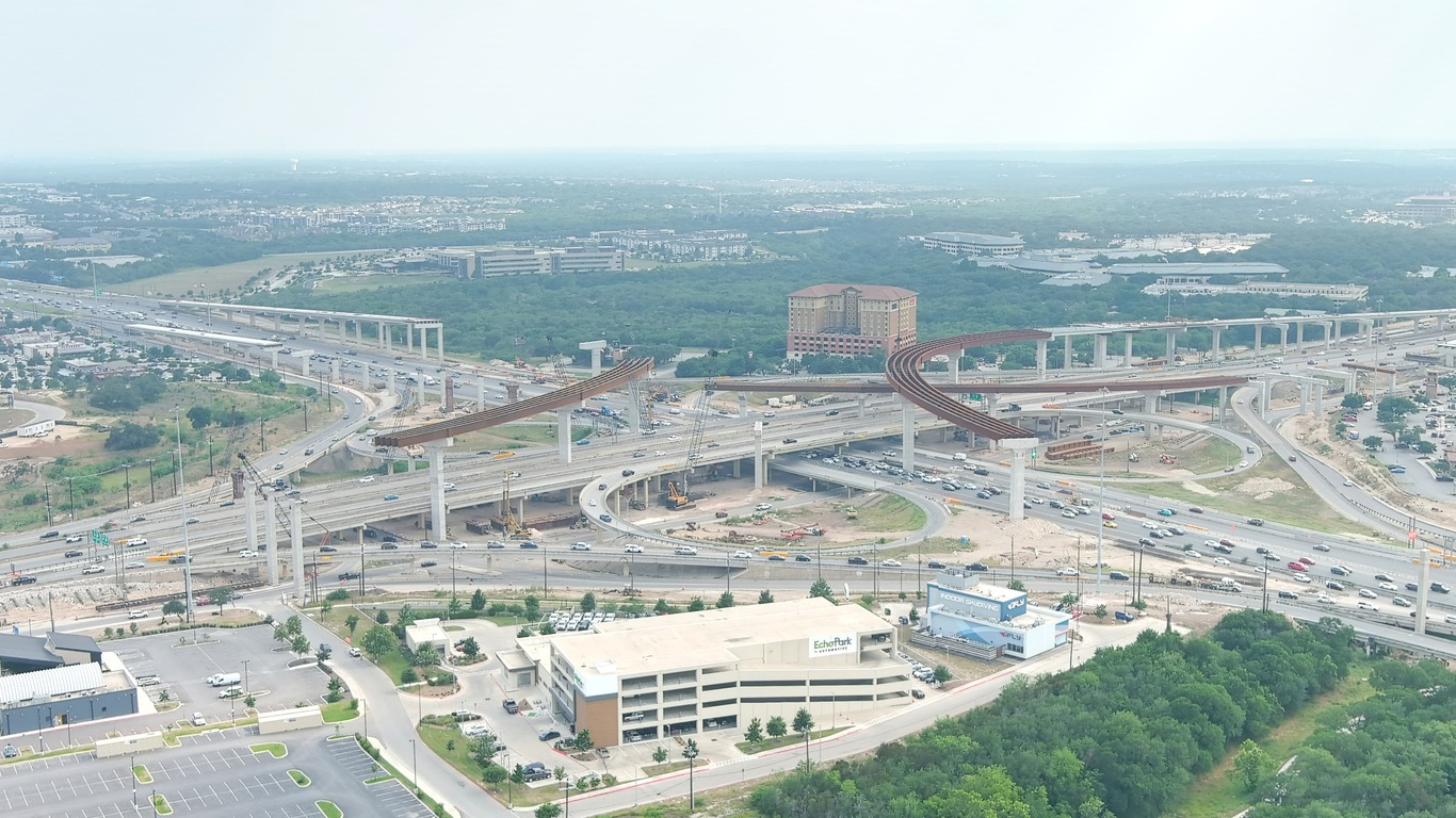
The most congested section of Interstate Highway in this system is Houston’s West Loop (I-610) between I-10 and I-69, handling tremendous traffic volumes with extended merging areas rather than relying on federal tollways or exclusive express lanes.
Economic Impact of Loop Highways on Texan Communities
Five decades of strategic highway loop development have transformed the economic landscape across the Lone Star State. You’ll find property values have surged along these corridors, from El Paso to Fort Worth, creating wealth and opportunity where TxDOT has invested in transportation infrastructure.
Loop highways haven’t just replaced older routes like the Old San Antonio Road; they’ve redefined commerce by reducing congestion and travel times. In West Texas and along the Gulf Freeway, businesses enjoy improved access to popular recreational areas and regional markets. These highways in the United States, particularly in Texas, have attracted diverse industries creating thousands of jobs.
The suburban expansion surrounding Fort Worth and other major cities demonstrates how loop construction has successfully connected residential communities to employment centers, driving sustainable economic growth.
The Future of Loop Systems in Texas Transportation Planning
As Texas cities continue their explosive growth into the 2030s, transportation planners at TxDOT are reimagining the next generation of loop systems with advanced technology integration. You’ll see major interstate connections adopting collector-distributor designs and express/local configurations to manage increasing traffic around Dallas, Houston, and other growing metros.
These highway improvements aren’t just about adding lanes. Transportation officials are weighing cost-benefit ratios and environmental impacts against alternative infrastructure projects. The future of Texas roads includes managed lanes that adapt to traffic conditions and infrastructure supporting connected/autonomous vehicles.
Loop systems connecting state parks and key economic centers remain indispensable for mobility as population swells. The United States’ fastest-growing state requires forward-thinking solutions to guarantee these essential arteries continue serving Texans efficiently for decades to come.