


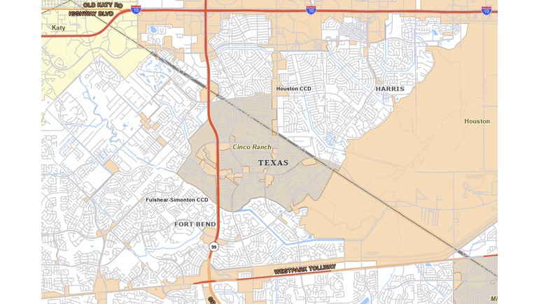
The 2024 Map of Cinco Ranch, Texas, provides a geographic view of the census-designated place located in the western Houston metropolitan area. Based on mapping data from the United States Census Bureau, the map identifies the boundaries of Cinco Ranch and its relationship to surrounding communities, roads, and geographic features. It offers a useful reference for understanding the location and development of this planned residential community.
Understanding Cinco Ranch
Cinco Ranch is a master-planned community located primarily in Fort Bend County, with portions extending into Harris County. Situated near Katy, west of Houston, the community has become a significant residential area within the rapidly developing suburbs of Greater Houston.
Unlike an incorporated city, Cinco Ranch is classified as a census-designated place (CDP). This designation allows the U.S. Census Bureau to collect and report population and demographic information for communities that do not have their own municipal governments.
The 2024 map illustrates the officially defined census area, which does not necessarily include every neighborhood or development commonly associated with the larger Cinco Ranch community.
Geographic Boundaries and Nearby Communities
One of the map's most important features is its representation of Cinco Ranch's census boundaries. These boundaries help distinguish the community from neighboring residential developments and surrounding unincorporated areas.
Cinco Ranch is located near several major transportation routes, including the Grand Parkway and Westpark Tollway. These roads provide connections to Katy, Houston, and other communities throughout the metropolitan region.
The surrounding area contains residential neighborhoods, schools, parks, commercial developments, and other facilities that support suburban living.
Residential Growth and Development
Cinco Ranch developed as a master-planned residential community, featuring neighborhoods organized around parks, recreational facilities, schools, and commercial centers.
Its growth reflects the broader westward expansion of the Houston metropolitan area during the late 20th and early 21st centuries. As employment opportunities and transportation infrastructure expanded, communities such as Cinco Ranch attracted residents seeking suburban housing with access to major employment centers.
The area has become closely associated with the development of the Katy region, one of the major suburban growth corridors west of Houston.
The Importance of Census Maps
Census maps play an important role in documenting the geographic boundaries used for population statistics and community planning. They help government agencies, researchers, and local organizations identify specific areas for demographic analysis.
The 2024 Cinco Ranch map is particularly useful because it represents the community according to federal geographic definitions rather than neighborhood names or real estate development boundaries.
These distinctions are important when comparing population figures, studying development patterns, or examining how census-designated areas change over time.
Geographic Importance of the Map
The 2024 Map of Cinco Ranch provides a useful reference for understanding the community's location within Greater Houston and its relationship to surrounding suburban development.
By identifying its census boundaries and nearby geographic features, the map helps illustrate how planned communities fit into the larger metropolitan landscape.
It also serves as a valuable resource for studying population distribution, suburban expansion, and the geographic organization of communities in Southeast Texas.