


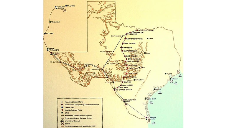
The Texas Frontier Line Civil War Map illustrates the network of military forts, camps, and defensive positions established across Texas during the American Civil War (1861–1865). Produced by Texas Parks and Wildlife in 1993, the map provides a historical overview of how Confederate and state forces organized frontier defenses during a period of military conflict and uncertainty.
Defending the Texas Frontier
When Texas seceded from the United States in 1861, federal troops withdrew from many military installations across the state. This left frontier settlements with reduced military protection, prompting Texas authorities to organize new defensive forces and establish military camps.
The map illustrates the frontier defense system, which extended from the Red River region in northern Texas toward the Rio Grande in the south. This network was intended to protect settlements from raids and other threats while Confederate forces were engaged in the Civil War.
Military Forts and Defensive Positions
One of the map's most notable features is its identification of military installations throughout Texas and parts of neighboring New Mexico. Locations such as Fort Belknap, Fort Chadbourne, Fort Mason, Camp Colorado, and Camp Cooper illustrate the importance of frontier outposts.
Different symbols distinguish abandoned federal forts, installations occupied by Confederate troops, federal forts, and newly established Confederate posts. These details help explain how military positions changed after Texas joined the Confederacy.
The map also shows the Union naval blockade along the Texas coast and the route of the Confederate invasion of New Mexico in 1862, providing a broader picture of military activity in the region.
Texas During the Civil War
Although Texas was geographically distant from many of the war's major eastern battlefields, it faced significant challenges along its western and northern frontiers. Military resources were limited, and state authorities had to balance frontier security with the Confederacy's demands for troops and supplies.
The Texas Frontier Regiment, organized in 1862, became an important part of these defensive efforts. Its soldiers patrolled frontier settlements and attempted to maintain security across a large and sparsely populated region.
Historical Importance of the Map
Today, the Texas Frontier Line Civil War Map provides a useful reference for understanding the state's military geography during the Civil War. It highlights the locations of frontier forts, the organization of defensive lines, and the challenges of protecting distant settlements.
The map also helps illustrate how the Civil War affected Texas beyond its major cities and coastal areas, particularly in regions where military outposts played an important role in settlement and frontier history.